In order to conveniently manage the settings for location-based services servers (LBS) and the AP locations by means of a WLC, you create the appropriate profiles for LBS servers via the menu and the button Advanced profiles.
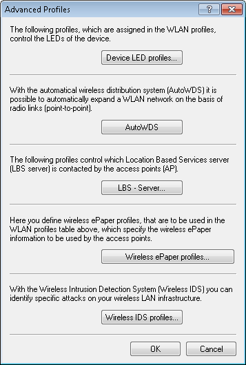
The button LBS - Server opens the dialog for creating a general LBS server profile.
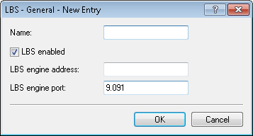
- Name
- Enter a descriptive name for the profile.
- LBS enabled
- Enable or disable LBS.
- LBS server address
- Enter the address of the LBS server.
- LBS server port
- Enter the port used by the LBS server (default: 9091).
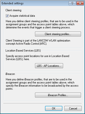
You create the corresponding profile for locations of the LBS APs under with the button Extended settings.
The button LBS - AP locations opens the dialog for creating a location profile for the LBS APs.
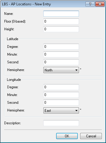
- Name
- Enter a descriptive name for the profile.
- Floor (0-based)
- Here you enter the floor on which the device is located. This allows you to differentiate between the top floor and bottom floor, for example.
- Height
- Here you enter the height of the device installation. It is possible to specify a negative value so that you can differentiate between a location above and below sea level.
- Degrees (latitude)
- This field specifies the angle in degrees of the geographic coordinate system.
- Minutes (latitude)
- This field specifies the minutes of the geographic coordinate system.
- Seconds (latitude)
- This field specifies the seconds of the geographic coordinate system.
- Hemisphere (latitude)
- This field specifies the orientation of the geographic coordinate system. The following values are possible for geographical latitude:
- North: Northerly latitude
- South: Southerly latitude
- Degrees (longitude)
- This field specifies the angle in degrees of the geographic coordinate system.
- Minutes (longitude)
- This field specifies the minutes of the geographic coordinate system.
- Seconds (longitude)
- This field specifies the seconds of the geographic coordinate system.
- Hemisphere (longitude)
- This field specifies the orientation of the geographic coordinate system. The following values are possible for geographical longitude:
- East: Easterly longitude
- West: Westerly longitude
- Description
- Enter a description of the device.